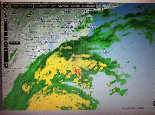
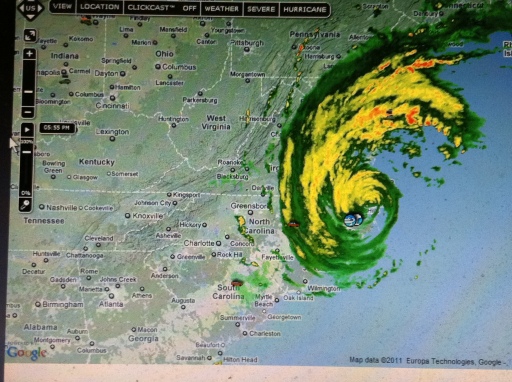
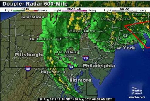
9:50 am Saturday Discovery.com allows you to track Hurricane #Irene. Watch for Periodic updates to this article to chronicle this storm from Stanczyk’s point of view. Today we should all crowd-source the chronicling of Irene, since somewhere between 10% and 20% of the American populace will be affected by Irene’s weather pattern. Are you game?
9:50 am Saturday
Satellite Photo –
This indicates the first bands are arriving in the Philadelphia area.
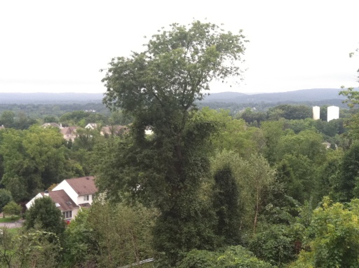
9:50 am Saturday Outside Window Photo.
No Rain
Wind 4mph
Humidity 95%;
Temp 75 degrees Fahrenheit
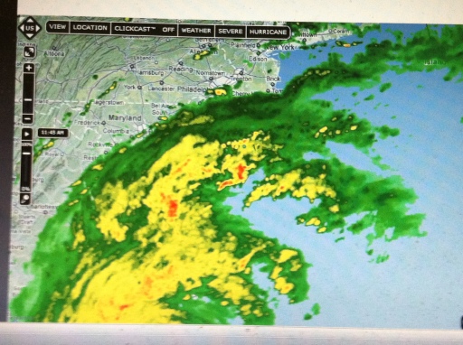
11:52 am Saturday The Satellite photo shows that the outer band has reached Philadelphia.
Well not much of a perceptible change outside from two hours ago, maybe a bit darker. I am hoping to determine the radar maps accuracy relative to me and my readings.
No Rain
Wind 4mph
Humidity 87%;
Temp 77 degrees Fahrenheit
Since Donna P. from the Blog, “Whats Past is Prologue” raised the question of media over-hype; Let me add a note.
Yesterday’s Philadelphia Inquirer published a graphic showing #Irene ‘s projected route/timeline. I noted it said, Landfall (pretty close to where the actual landfall actually occurred) would happen at 14:00. The actual time of landfall was 07:30. The projected arrival was to be a day later in Philly. So I will see whether it arrives in Philly at 07:30 Sunday or not. All times are Eastern US timezone.
12:50 Saturday Previously in my comment to Donna P. I had said I’d compare to Hurricane Hugo (which happened in 1989). But I meant Hurricane Floyd in 1999 is the one in my mind that I wanted to compare.
From wikipedia in 1999 Hurricanes, we see that Floyd came ashore in ” Cape Fear as a Category 2 storm on September 16. It returned to the ocean near Norfolk, Virginia, and traveled up the coasts of the Delmarva Peninsula and New Jersey as a tropical storm. It passed over Long Island and into New England.[32] Floyd caused record rainfall across the east coast, with Wilmington, North Carolina, and Philadelphia, Pennsylvania, setting 24-hour rainfall records of 15 in (380 mm) and 6.63 in (168 mm) in respectively. Portions of New England had rainfall totals nearing 11 in (280 mm). Floyd generated 9 to 10 ft (2.7 to 3.0 m) storm surges across North Carolina. There are 57 deaths directly blamed on Floyd, 56 in the United States and one on Grand Bahama. Most of the deaths were due to freshwater flooding in North Carolina. Floyd was one of the costliest hurricanes on record, with an estimated $4.5 billion (1999 USD; $5.93 billion 2011 USD) in damage.”
For comparison, we look at the Discovery.com website and we see the a prediciton on cost damages has already been made:
“Kinetic Analysis Corp., a company that does computer modeling of predicted storm damage, predicted on Friday[8/26/2011] that Irene would cause $5-10 billion in damages, based on the latest available weather data. ”
So it would appear that a Floyd comparison may be a sound benchmark to compare with afterall.
14:47 Saturday Well the rain started about an hour and five minutes ago (while I was at the supermarket 😉 ). It was busy and many items were sold out. The supermarket manager was heard saying what the contingencies would be if the power went out to his subordinate — so we are all preparing for #Irene.
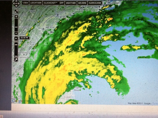
The Satellite now shows the forward band extended out past Philly and out all the way to Harrisburg — so I guess the rain should be happening (as I indicated the rain started about 13:42).
My outside image is the last I will now be able to take from outside. The remainder will have be shot through windows.
Rain Total: 0.03″ [inches]
Wind: 6mph[variable 0-6mph]
Humidity: 98%
Temp: 75 degrees Fahrenheit
18:00 Saturday If you look closely at the 18:00 Satellite image you will see that the entire Eastern Seabord from North Carolina to Connecticut is now covered by Hurricane #Irene or its bands of rain/wind.You can now see all Harrisburg again so the cone up here seems narrower while more completely covered. In fact the bands are now indistinct — just seems to be one great big mass of rain — less wind then in most of our thunderstorms.
Here by me the region has 5 flood warnings and one Tropical Storm Warning (Irene is supposed to be slower up here and this far inland from the coast) so it will lose Hurricane status when it does arrive here.
Well the weather outside has not changed much — still rainy. The Temps are fluctuating up/down a degree or two.
No image of the outside this time [same as before but darker as we approach dusk].
Rain Total: 0.30″ [inches]
Wind: 2mph[fairly steady]
Humidity: 100%
Temp: 72 degrees Fahrenheit although it had dropped as far as 71.
19:34 Saturday No new Satellite image. Hurricane #Irene is moving slowly. It is about Newport News, VA (partially offshore. Here by me the region now has 6 flood warnings and one Tropical Storm Warning .
Darkness has descended and the weather outside has changed only slightly — still rainy. The Temps are at projected low (71 degrees).
Rain Total: 0.72″ [inches]; Wow quite a change in 90+ minutes it more than doubled.
Wind: 1-12mph[variable, mostly 5-10mph]
Humidity: 100%
Temp: 71 degrees Fahrenheit.
21:21 Saturday No new Satellite image. Hurricane #Irene is moving slowly. It is about Newport News, VA (partially offshore. Here by me the region still has the same 6 flood warnings and one Tropical Storm Warning .
Rain Total: 1.12″ [inches]; In less than 60 minutes we added 0.4″ of rain to the total.
Wind: 4-15mph[most of evening we have had gust in 20+ mph range]. Now we have mostly double-digits wind speed though it seems awfully variable. Data Collector is not realtime so I have not seen the gust speeds, but I have heard them outside.
Humidity: 100%
Temp: 70 degrees Fahrenheit. 1 degree below earlier predictions.
Next update tomorrow morning.
04:19 Sunday No new Satellite image. Too early for that rigamarole. Lats night, shortly after sign-off we lost power twice in quick succession, both outages very short in duration. Kudos to PECO.
Let me see what data is still available to be shared. I have not yet turned on the TV. The very fact we have power and a connection to the Internet is a blessing. Moja zona and our dog Java are safe and sound so far — Thanks be to God.
Rain Total: Yesterday’s rainfall total is yet unknown. Sunday’s total to this point: 0.28″
Wind: 5 mph. I can only assume by such low wind speeds that #Irene ‘s eye must be near my location.
Humidity: 100%
Temp: 71 degrees Fahrenheit.
Next update will occur after I collect some data. Possibly shortly. So far the effects of Irene seem to have been exaggerated, except for that period when we lost power for a few minutes. I am leaning to media and government over-hype — This is not as bad Floyd so far.
05:08 Sunday No new Satellite image. Too early for that rigamarole. Tornado watch just expired (uneventfully) for my area. Picked up another flood warning overnight so we still 7 flood warnings and 1 tropical storm warning in my area.
I was correct that the eye of #Irene is about Atlantic City, NJ (which east and a bit south of Phill). So that explains the relative slow winds speeds I am seeing/hearing. It appears that Irene’s greatest affect have been at the shore and the further inland you were the better off you were wind-wise — flooding has been worse inland. Storm surge at the shore is bad and especially so during the high tides. Irene being so slow, that two high tides can occur. during the event horizon. So Shore flooding and beach erosion have been problems –hence the necessity of evacuation orders.
Still it seems more people have died from falling trees or tree branches — why are you outside? One of those fatalities was actually indoors.
Rain Total: Yesterday’s rainfall total is yet unknown. Sunday’s total to this point: 0.46″. An impressive 0.18″ increase in less than 1 hour. They are calling for 1-4″ (two sources: one says 1-2″ more and the other says 2-4″ more). Best I can determine is that 1.88″ fell yesterday in my area. Do not know the accuracy of that as I suspect it was higher as we were getting about 0.40″ inches an hour when I stopped recording yesterday night and it was accelerating still.
Wind: Variable 5-13 mph. Eye near my location. Gusts into the 20’s though I have heard them my data collector has not measured them (due to it not being continuous I am sure).
Humidity: 100%
Temp: 70 degrees Fahrenheit. It appears we have been in the 70-71 degree range for hours now — fairly cool for this time of year. It is a 15-19 degree drop since the weather pattern entered the area.
08:58 Sunday Satellite image shows that #Irene has left town; Uneventfully for my area. We still have 7 flood warnings in my area. The flooding will continue throughout Sunday as water flows down from the North down the rivers and bays back into the ocean.
The local TV and emergency responders say that this was not as bad as Floyd [so even others are comparing Irene to Floyd].
A final note: We lost power a 3rd time since my last post but only for a few minutes.
Rain Total: Yesterday’s rainfall total was 2.98-6.33″ depending on source. Sunday’s total to this point: 0.98″. Most sources say 2-4″ are likely for Sunday. We are way past the rainfall record books for August in history of Philadelphia area and we still have three days to go after today.
Wind: Variable 6-10 mph. Gusts into the 30’s though. It looks like a trailing band [down in Baltimore] will still bring some more wind until Irene fully clears the greater Philadelphia area.
Humidity: 100%
Temp: 67 degrees Fahrenheit. That is fairly cool for this time of year. It is over a 20 degree drop since the weather pattern entered the area.
Blessings and Thanks to God for my good fortune. Things could have been much worse and I had little time/resources to prepare/protect my family from this disaster (#Irene).


